Description and History of Site:-
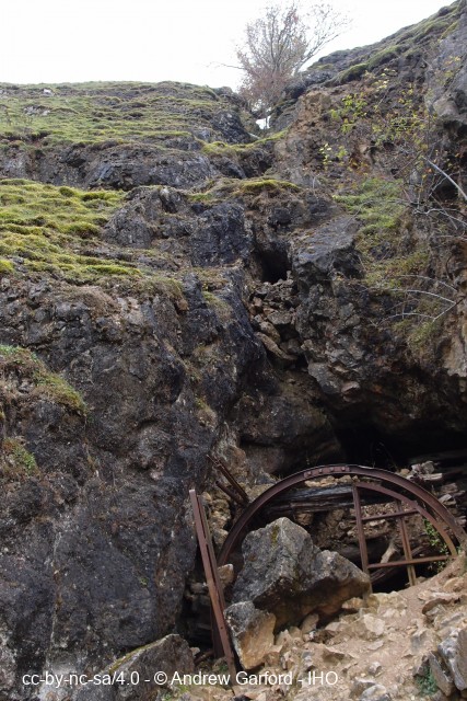
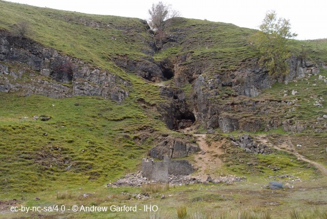
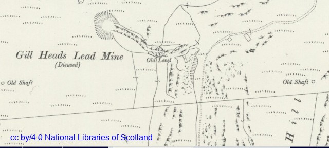
A lead and fluorspar mine in which the main workings were driven into the ore vein on three horizons from the valley side on the western branch valley of Trollers Gill near Skyreholme. Some exploratory bell shafts were also sunk along the vein towards Dibbles Bridge which were known locally as 'The Hen and Chicks'. The mine is reputed to have produced large tonnages of lead ore over the years but not all the mines production figures are available to substantiate this. Although it is not known the date in which work started on this vein, 'later workings broke through into an old, small section, and very torturous level probably driven from the valley bottom with all aspects suggesting very early workings' (A. Raistrick).
In 1857 it was included in the lease of the Appletreewick Lead Mining Co and in 1875 the mine was being worked by the Appletreewick Gill Mining Co with William Newbould as Agent. A new company, the Appletreewick Gill Heads Mining Co, formed by Samual Pullan in 1877, was working via the Middle Level with William Newbould still as Agent but little ore was being produced.
Between 1882-97 the New Appletreewick Mining Co was working the mine with six men underground.
In 1898, J.S. Winn formed the Gill Heads Mining Co and held the mine until 1900.
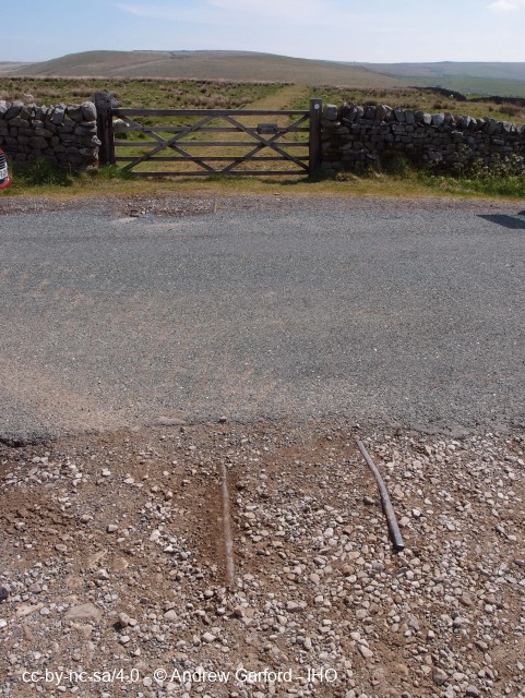
Soon after 1915 a Mr Clay and the Greenhaugh Mining Co opened out the vein on the side of the gill, soon developing a very large stope almost to the top of the valley side, still visible today (2020) from the public footpath, a stope being the cavity which exists on the removal of the ore and backfilled with the tailings, or waste rock, and often supported by a timber construction, similar to a shelf, to enable mining to take place as the working face progresses. Lead ore and Fluorspar were brought out at the new mouth a little above the valley floor and hauled up a very steep incline tramway to a loading bay near the Appletreewick to Pateley Bridge road. Large quantities of Fluorspar were produced, somewhere around 15,000 tons, most of which was sent to America being loaded as ships ballast.
On another vein in the Dibb Valley a mile to the south west, which had some former mine workings reopened and became mechanised. The white Calcite being mined there was sold as pebble dashing after being washed and sized. This mine was connected to Gill Head by a railway operated by Greenhaugh Mining Co across Appletreewick Pastures leading to a very steep steam-winch controlled incline to the Gill Head Mine where the dressing plant was situated. The Calcite was transported across the pasture in tubs hauled by a Sentinel steam loco and later a petrol engined loco.
The Gill Head Mine produced good quality Fluorspar but due to the low prices prevailing the mine closed in 1924. As prices fluctuated the mine was worked again by a Mr F. Walker.
In the 1960's the Clay Cross Co removed most of the tips from Gill Head for treatment at their nearby Dry Gill plant being completed by 1967.
The mine was worked further in 1974-5 when Russom and Co worked a wing deposit near the entrance to the Middle Level achieving approximately 2,135 tons of Fluorspar.
In 1980-81 the Wharfedale Mining Co did some work, although the vein was four feet wide and carried Fluorspar, increasing amounts of Calcite lowered the grade beyond economic viability leading to the mine being finally abandoned.
Further Reading and References:-Lead Mining in the Mid-Pennines, Arthur Raistrick, Bradford Barton Ltd, 1973 pp74-5
British Mining No 21 The Greenhow Lead Mining Field, NMRS 1983, M.C.Gill, J.M. Dickinson pp15-16
Mines and 't Miners, J.M. Dickinson 1972 pp38-39
Help us improve this entry
The compilers welcome corrections or additional information on all sites.
Any information provided will be verified before appearing on the web site.
Email comments
Key Words :- lead mine fluorspar
Viewing the Site :- Public footpath runs alongside the workings but they are unstable and should only be viewed from a safe distance.
Address :- Appletreewick, Skipton, North Yorkshire
Grid Ref :- SE 06607 62052
Co-ordinates :- Lat 54.054384 , Long -1.900569
Local Authority :- Craven District Council
Pre 1974 County :- Yorkshire - West Riding
Site Status :- Site extant - Protected status unknown
Site Condition :- Site derelict - some buildings remaining
Site Dates :- - 1981
Record Date :- 18 April 2020
Copyright :- cc-by-nc-sa 4.0 © Andrew Garford