Industrial History Online
Moorgate Station
Key Words :- railway station
Address :- Moorgate, London, Greater London, EC2
Grid Ref :- TQ 326 816
Co-ordinates :- Lat 51.517766 , Long -0.090314
Local Authority :- City of London
Pre 1974 County :- Greater London Council
Site Status :- Site extant - Protected status unknown
Description and History of Site :-
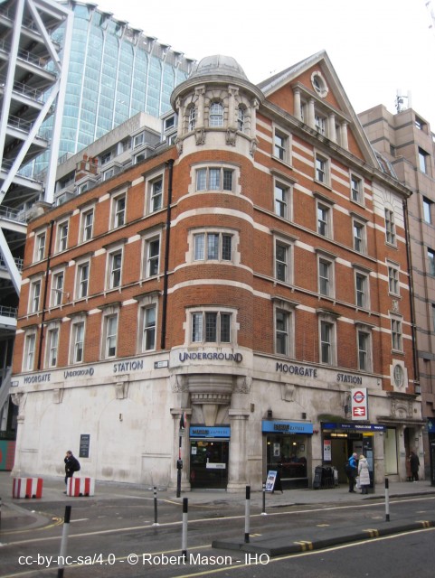
Joint station with London Transport through lines on the Circle line between Barbican and Liverpool Street tube stations, and terminating lines currently (2004) used by Thameslink trains southbound from a junction at Farringdon Station.
The terminating lines ended in blind ended tunnel, and one of these at 8.46 am on 28 February 1975 was the scene of one of London's worst railway accidents when a rush-hour LT underground Northern Line train over-ran the platform and crashed into the headwall of the blind tunnel. Three crowded coaches were telescoped into the blind tunnel. The final death toll was 43. This part of the station was closed 1 March 1975, and reopened as a BR station 8 November 1976.
The former Great Northern and City tube line from Finsbury Park also terminates at this station and the 1975 crash occurred on this line and not at the subsurface Thameslink platforms. The former City and South London headquarters building is near the station entrance in Moorgate.
Further Reading and References :-
No references for this site
Help us improve this entry
Grid Ref :- TQ 326 816
Co-ordinates :- Lat 51.517766 , Long -0.090314
Local Authority :- City of London
Pre 1974 County :- Greater London Council
Site Status :- Site extant - Protected status unknown
Joint station with London Transport through lines on the Circle line between Barbican and Liverpool Street tube stations, and terminating lines currently (2004) used by Thameslink trains southbound from a junction at Farringdon Station.
The terminating lines ended in blind ended tunnel, and one of these at 8.46 am on 28 February 1975 was the scene of one of London's worst railway accidents when a rush-hour LT underground Northern Line train over-ran the platform and crashed into the headwall of the blind tunnel. Three crowded coaches were telescoped into the blind tunnel. The final death toll was 43. This part of the station was closed 1 March 1975, and reopened as a BR station 8 November 1976.
The former Great Northern and City tube line from Finsbury Park also terminates at this station and the 1975 crash occurred on this line and not at the subsurface Thameslink platforms. The former City and South London headquarters building is near the station entrance in Moorgate.
The compilers welcome corrections or additional information on all sites.
Any information provided will be verified before appearing on the web site.
Email comments
Contributor :- GLIAS Database - 2 June 2018
Copyright :- cc-by-nc-sa 4.0 © GLIAS Database
Copyright :- cc-by-nc-sa 4.0 © GLIAS Database